The PBS series NOVA, “Rise of the Drones,” recently aired a segment detailing the capabilities of a powerful aerial surveillance system known as ARGUS-IS, which is basically a super-high, 1.8 gigapixel resolution camera that can be mounted on a drone. As demonstrated in this clip, the system is capable of high-resolution monitoring and recording of an entire city. (The clip was written about in DefenseTech and in Slate.)
In the clip, the developer explains how the technology (which he also refers to with the apt name “Wide Area Persistent Stare”) is “equivalent to having up to a hundred Predators look at an area the size of a medium-sized city at once.”
ARGUS produces a high-resolution video image that covers 15 square miles. It’s all streamed to the ground and stored, and operators can zoom in upon any small area and watch the footage of that spot. Essentially, it is an animated, aerial version of the gigapixel cameras that got some attention for super-high resolution photographs created at Obama’s first inauguration and at a Vancouver Canucks fan gathering.
At first I didn’t think too much about this video because it seemed to be an utterly expected continuation of existing trends in camera power. But since it was brought to my attention, this technology keeps coming back up in my conversations with colleagues and in my thoughts. I think that’s because it is such a concrete embodiment of the “nightmare scenario” for drones, or at least several core elements of it.
First, it’s the culmination of the trend towards ever-more-pervasive surveillance cameras in American life. We’ve been objecting to that trend for years, and many of our public spaces are now under 24/7 video surveillance—often by cameras owned and operated by the police. But even in our most pessimistic moments, I don’t think we thought that every street, empty lot, garden, and field would be subject to video monitoring anytime soon. But that is precisely what this technology could enable. We’ve speculated about self-organizing swarms of drones being used to blanket entire cities with surveillance, but this technology makes it clear that nothing that complicated is required.
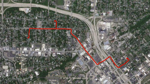
Second and more significantly to me, this technology also makes real a key threat that drones pose to privacy that we've talked about: the ability to do location tracking. The video shows cars and pedestrians near Quantico, Virginia automatically tagged with colored boxes, which follow them as they move around. As the technology’s developer told NOVA,
Everything that is a moving object is being automatically tracked. The colored boxes represent that the computer has recognized the moving objects. You can see individuals crossing the street, you can see individuals walking in parking lots.
The surveillance potential of such a tracking algorithm attached to such powerful cameras is worth pausing to think about. To identify someone there’s no need for face or license-plate recognition (which may be impractical from above anyhow), cell phone tracking, gait recognition, or what have you. Even knowing where a little green square starts and finishes its day can reveal a lot, because it turns out that even relatively rough location information about a person will often identify them uniquely. For example, according to this study, just knowing the zip code (actually census tract, which is basically equivalent) of where you work, and where you live, will uniquely identify 5% of the population, and for half of Americans will place them in a group of 21 people or fewer. If you know the “census blocks” where somebody works and lives (an area roughly the size of a block in a city, but much larger in rural areas), the accuracy is much higher, with at least half the population being uniquely identified.
However, ARGUS-type tracking could be used to get more precise data than that—in many cases, to determine a vehicle’s home address, which pretty much reveals who you are if you’re in a single-family home, and narrows it down pretty well even if you’re in a large apartment building. (Academic papers have been written on inferring home address from location data sets.) Add work address and I expect that would nail virtually everybody. And of course lodged in the data set would be not just where a particular vehicle starts and finishes its day, but all the places it stopped in between—potentially revealing, as we so often point out, an array of information about a person such as their political, religious, and sexual activities.
True, such tracking using ARGUS would be disrupted whenever a subject disappears from aerial view. For example, pedestrians who travel by subway or bus or walk under foliage, or vehicles entering tunnels, would be harder to track. But even there, datamining large data sets collected over time could probably reveal a lot of things about people’s daily patterns and I would bet could eventually be used to identify a surprisingly large number of them. I expect that ARGUS would be used (if it’s not already) to generate a database consisting of location tracks of moving vehicles or pedestrians beginning in one place and ending in another. Think of them as little strings on a map. Some of these strings would stretch from a person’s home to their work, with stops in between, while others might be fragments, interrupted by a tunnel or other obstruction. But even the fragments, when the dimension of time is added to the equation, could probably be correlated together.
Of course low-lying clouds or fog might also interfere with aerial tracking, though imaging technologies already in existence could probably be deployed to see through them.
NOVA was not allowed to show images of the ARGUS censor, and stated that part of the program remained classified, including whether it has yet been deployed. (Though, we know it has been deployed domestically at least once, over Virginia as shown on NOVA. I’m going to assume it has not been deployed domestically in any more routine manner.) But, it is good that the Air Force allowed NOVA to see its capabilities. I’d like to think it’s because as Americans, Air Force officials have respect for our country’s values and democratic processes and don’t want to let such powerful and potentially privacy-invasive tools to be created in secret. It could also be, however, because the Air Force needs private-sector help in figuring out how to analyze the oceans of data the device can collect (5,000 hours of high-def video per day).
Either way, it’s important for the public to be aware of the kinds of technologies that are out there so that it can better decide how drones should be regulated.
Related Issues
Related Content
-
Press ReleaseJul 2026

National Security
Free Speech
Florida Officials Pause Designation Of Prominent Civil Rights Groups As “terrorist Organizations”. Explore Press Release.Florida Officials Pause Designation of Prominent Civil Rights Groups as “Terrorist Organizations”
TALLAHASSEE, Fla. — Last night, Florida officials paused their plan to designate the Council on American-Islamic Relations (CAIR) as a “domestic terrorist organization,” under new laws that went into effect on July 1. This development comes in a lawsuit that the American Civil Liberties Union, the Southern Poverty Law Center, and their partners filed on behalf of the civil rights nonprofit and its Florida chapter after Gov. DeSantis and other state officials announced they would quickly move to designate CAIR. According to a court filing, the Florida Department of Law Enforcement now intends to issue regulations to implement the laws, and “no designation will be made before the regulations are finalized.” Lawyers for Gov. DeSantis and other defendants in the lawsuit stated they could not yet provide a timeline on when these regulations would be finalized, and the parties will report again to the court by July 22. “From day 1, Florida officials’ use of this dangerous new designation regime has violated the Constitution. Gov. DeSantis has simply no legitimate basis to brand our clients with one of society’s most reviled labels let alone to force them to shut their doors under threat of crippling criminal penalties, and leave the Floridians they serve without a crucial civil rights voice,” said Hina Shamsi, director of the ACLU’s National Security Project. “In the United States, CAIR and all nonprofits have the right to criticize the government, protect religious freedom, and advocate for the causes they believe in.” In April 2026, Gov. DeSantis signed into law HB 1471 and HB 1473 despite public outcry. These laws establish an unprecedented state designation regime and dramatically expand Florida’s authority to both label and punish groups — including nonprofits engaged in First Amendment-protected advocacy — that officials unilaterally decide are security threats. Under the regime, officials can brand nonprofit corporations with debilitating stigma and then use an array of state authorities to immediately silence and incapacitate the organization, its employees, and a wide range of others associated with the group through extraordinarily broad and severe criminal, civil, and administrative penalties. On July 2, the nonprofits’ legal team filed an emergency motion asking the federal court to prevent the designation from going into effect and to allow the groups to litigate the challenge without fear of prosecution under the broad designation laws. The court denied the emergency filings, stating it required further briefing and evidence that Florida officials were following through on their threats. “The fact that Florida officials announced their intent to designate CAIR at their July 1 press conference, before regulations they now plan to issue have come into effect, shows their calculated and cruel plan to designate CAIR is not because it is in any way a threat to public safety, but because doing so suits their political agenda,” said Scott McCoy, deputy legal director, Southern Poverty Law Center. “The State’s decision to negatively brand CAIR has already violated its constitutional rights and inflicted immediate and ongoing harm to it.” CAIR and CAIR-FL are represented in the suit by the American Civil Liberties Union, the ACLU of Florida, the Southern Poverty Law Center, Akeel & Valentine, PLC, and Bondurant Mixson & Elmore LLP. -
News & CommentaryJul 2026
Free Speech
+3 Issues
Todd Blanche's Record Raises Alarming Questions About The Future Of Doj. Explore News & Commentary.Todd Blanche's Record Raises Alarming Questions About the Future of DOJ
With Acting Attorney General Todd Blanche set to appear before the Senate for a hearing to potentially confirm him to the post, senators have no shortage of questions to ask about his record. -
FloridaJul 2026

National Security
+2 Issues
Cair-foundation, Inc And Cair Florida, Inc. V. Desantis Et Al.. Explore Case.CAIR-Foundation, Inc and CAIR Florida, Inc. v. DeSantis et al.
The ACLU, the ACLU of Florida, the Southern Poverty Law Center, and their partners represent CAIR and CAIR-Florida in two federal lawsuits challenging Governor DeSantis’s unconstitutional and baseless designation of the nonprofits as “terrorist.” The lawsuits allege violations of CAIR and CAIR-Florida’s rights under the First Amendment and the due process clause of the Fourteenth Amendment. -
Press ReleaseJul 2026
National Security
Free Speech
Muslim Civil Rights Nonprofits Sue Florida Officials To Prevent Unconstitutional Designation That Threatens The Organizations’ Existence In The State. Explore Press Release.Muslim Civil Rights Nonprofits Sue Florida Officials to Prevent Unconstitutional Designation that Threatens the Organizations’ Existence in the State
TALLAHASSE, Fla. — The American Civil Liberties Union, the ACLU of Florida, Southern Poverty Law Center, Akeel & Valentine, PLC, and Bondurant Mixson & Elmore LLP today filed a federal lawsuit challenging Florida officials' imminent and baseless designation of the Council on American-Islamic Relations (CAIR) as a “domestic terrorist organization” under laws that went into effect today. The challenge comes hours after Gov. Ron DeSantis announced his intent to use the new laws against CAIR, one of America’s leading civil rights organizations. Although the governor did not mention CAIR-Florida, he has previously indicated that he also considers it a “terrorist organization.” If the nonprofits are designated, they face immediate and irreparable harm, including the shuttering of all their operations and advocacy in the state. In April 2026, Gov. DeSantis signed into law HB 1471 and HB 1473 despite outcry. These laws establish an unprecedented state designation regime and dramatically expand Florida’s authority to both label and punish groups — including nonprofits engaged in First Amendment-protected advocacy — that officials unilaterally decide are security threats. Under the regime, officials can brand nonprofit corporations with debilitating stigma and then use an array of state authorities to immediately silence and incapacitate the organization, its employees, its members, and a wide range of others associated with the group through extraordinarily broad and severe criminal, civil, and administrative penalties. “We thank the ACLU, SPLC, Akeel & Valentine, and Bondurant for standing up against Gov. DeSantis’ latest attack on the rule of law,” said CAIR’s national headquarters. “Throughout CAIR’s long history, our civil rights organization has worked to protect the Constitution’s guarantees of free speech, religious freedom and equality under the law. We have also pursued justice for all people, including American Muslims impacted by hate. This is exactly why Gov. DeSantis has repeatedly targeted our organization. We see through Gov. DeSantis’ latest biased attempt to punish us for our views and our values. We look forward to fighting these baseless attacks in court and proving once again that the Constitution is stronger than any politician’s bigotry.” Targeted organizations can receive no meaningful notice and have no meaningful opportunity to challenge the designation before a neutral decisionmaker — and before the designation and harsh penalties take effect. “Under Florida’s dangerous new regime, the governor and a few officials can play judge, jury, and nonprofit executioner. But the Constitution does not allow elected officials to punish American nonprofits and deny them the fundamentals of due process because of disagreement with their views,” said Hina Shamsi, director of the ACLU’s National Security Project. “Florida’s imminent designation of our clients is both dire and unmoored from reality. CAIR and CAIR-Florida’s speech and advocacy are protected by the First Amendment, which includes their right to criticize the governor, other officials, and their policies. We’re asking the court to protect our clients’ cardinal freedoms.” As the lawsuit explains, CAIR and CAIR-Florida are nonprofits organized under the laws of the District of Columbia and Florida. They do not engage in “terrorist activity.” Their shared mission, rooted in faith, is to enhance the public’s understanding of Islam, protect civil rights, promote justice, and empower American Muslims. Like other prominent nonprofits, they hold community events, post educational materials on social media, speak about elected leaders, and represent clients in advocacy and civil rights lawsuits. They have not been charged with, let alone convicted of, a crime. “Like any other faith-driven nonprofit, we host community events to promote religious tolerance and understanding, provide cultural education, and our work seeks to advance public policy that protects the equal treatment of Muslim Americans,” said CAIR-Florida. “Our work is critical to combatting prejudice, false stereotypes, and ensuring the promises of the Constitution cover us all — yet the governor has unfairly labeled us something we are not and threatens our very ability to continue this crucial work. We all share the same rights, and no group should be targeted simply because the governor disagrees with their constitutionally protected speech.” If the designation goes into effect, its impact will be instant and incapacitating for CAIR and CAIR-Florida’s work in the state. Specifically, the lawsuit claims that they would be caught in a kaleidoscope of criminal prohibitions that would stop them from carrying out even their most basic functions in Florida. Put bluntly, designation will completely shut down their speech, force them to shutter their offices in the state, and brand them with one of the most stigmatizing, infamous labels in our country. On top of the reputational and operational harm, the designation would also violate their right to counsel. That’s because, once designation becomes effective, any lawyer or legal organization that provides or attempts to provide legal services or representation to CAIR or CAIR-Florida faces a credible threat of criminal prosecution under this regime. “Florida’s attack on the largest Muslim civil rights organization in the country is dangerous and wrong,” said Daniel Tilley, legal director of the ACLU of Florida. “If we allow this undisguised attempt to restrict constitutionally protected speech and association to go unchallenged, it only ensures that the increasingly normalized censorship and discrimination at the hands of our state government will expand ever further.” The groups are suing under the First Amendment and the due process clause of the Fourteenth Amendment. “Gov. DeSantis does not have the power to unilaterally brand an organization with this vilifying designation and punish those who support it without due process or judicial review,” said Scott McCoy, deputy legal director, SPLC. “Denying due process and suppressing and punishing constitutionally protected speech and advocacy are clear violations of both the First and Fourteenth Amendments. SPLC will not stand idly by while civil rights groups like CAIR and CAIR-Florida have their rights trampled based on unfounded fear and prejudice by politicians trying to score political points.” CAIR and CAIR-Florida are also separately suing Florida officials over a related executive order that Gov. DeSantis was trying to use to target the nonprofit. In early March 2026, the U.S. District Court for the Northern District of Florida granted CAIR's request for a preliminary injunction blocking enforcement of his “blatantly unconstitutional” executive order, which unilaterally branded CAIR a “terrorist organization,” and would have stripped CAIR — and those associated with the group — of state and local contacts, employment opportunities, funding and other public benefits. Gov. DeSantis has since appealed to the Eleventh Circuit Court of Appeals. The complaint in the lawsuit can be viewed here.